|
|
 |
The term watershed
describes an area of land that drains downslope to the lowest point. Water moves through a network of drainage pathways, both underground and
on the surface. These pathways converge into streams and
rivers, which become progressively larger as the water moves on downstream, eventually reaching the ocean. Other terms used
interchangeably with watershed include drainage basin or catchment basin.
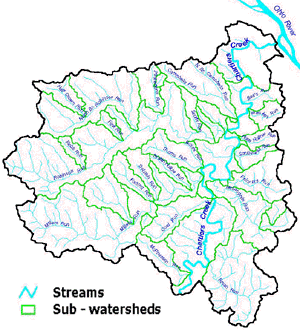
The Chartiers
Watershed is the total geographic land area that drains water, sediment
and dissolved materials by the network of tributaries that feed the main
channel of Chartiers Creek. The Chartiers Creek Watershed comprises
280 square miles. Chartiers Creek runs for 52 miles, beginning 6 miles
south of Washington, PA, and flows into the Ohio River at McKees Rocks, 3 miles
downstream of Pittsburgh. Chartiers Creek runs from an elevation of 1200 feet to
700 feet above sea level at the Ohio River. |
|
|
It is
relatively easy for you to delineate watersheds using a topographic map that shows
stream channels. Watershed boundaries follow major ridgelines around
channels and meet at the bottom, where water flows out of the watershed,
into a stream or river.
Watersheds can be
large or small. Every stream, tributary, or river has an associated
watershed, and small watersheds join to become larger watersheds. Two large sub-watersheds are delineated within
the Chartiers Watershed - the Upper Chartiers Watershed and the Lower
Chartiers Watershed. The lower watershed, comprised of the
sub-watersheds downstream of the
confluence of Little Chartiers Creek and Chartiers Creek in Washington
County, an area approximately 139 square miles in size, is shown in
the map at right.
|
|
|
HYDROLOGICAL
CYCLE
|
|
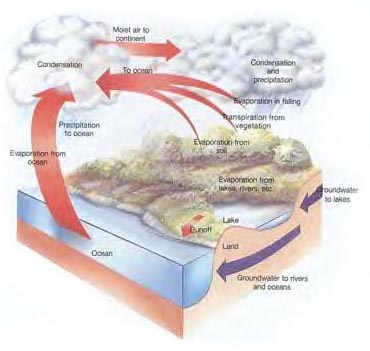
The
hydrological cycle is a basic process of water cycling that is
crucial to all life on earth. Precipitation waters crops for us to
eat, replenishes streams, lakes, and wetland habitats, supports the
growth of forests and recharges the groundwater that provides
the water we drink. Evaporation withdraws water from earth and
stores it in the atmosphere as clouds, until weather conditions
stimulate a rain shower.
The drainage system includes the geographic area surrounding the stream
system that captures precipitation, filters and stores water, and
determines water release into stream systems. The stream system is the
visible, aboveground portion of this larger drainage system. |
|
The connectivity of
the stream system refers to the physical connection between tributaries
and the river, between surface water and groundwater, and between wetlands
and water. Connectivity is the primary reason for doing aquatic
assessments at the watershed level. Because water moves downstream,
any activity that affects the water quality, quantity, or rate of movement
at one location can affect locations downstream. For this reason, everyone
living or working within a watershed needs to cooperate to ensure good
watershed conditions. |
|
|
|
Floodplains
are nature's method of disaster damage control. Not all ecosystems can
tolerate inundation, or the damage and destruction left by raging
floods. Floodplains are special parts of the valley where rising
waters can flood. Specially evolved plant communities occupy these
areas. Grass-like sedges and rushes capture rushing sediments and help
stabilize the stream banks. Trees like red maples and box elders like
to grow with their roots in water, and can re-sprout from these roots
if their trunks get broken by rushing debris during a flood. Other
trees like sycamores are strong and solid and can withstand many
floods. |
 |
|
Rivers
and streams overflow predictably into the floodplain. This fact makes
building in the floodplain a very dangerous option. Even building on a
natural terrace slightly above the floodplain could spell disaster in
the next 100 years.
The
illustration below shows the probable extent of flooding over
long time intervals on a hypothetical floodplain similar to the
Chartiers Creek floodplain.
|
|

|
The
2-3 year flood inundates the existing floodplain (Terrace 1). It
is only this flooding which the Fulton Flood Control Project was
designed to eliminate. The 100 year flood inundates both
the existing floodplain and a higher one (Terrace 2), which
formed when the river stood at a higher level.
|
|
The
500 year flood event inundates an even higher terrace and all
lower terraces and floodplains. This is the event presumed
to have happened during Hurricane Ivan. However, that
assumption was based on traditional land use patterns where
there was less runoff than with current land use and
development.
After
many flooding disasters, the government has realized the danger
and expense of building on floodplains. Some regulations
restrict the construction of new buildings within certain limits
of the floodplain.
|
|
|
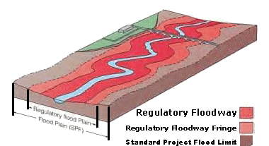
In
the illustration above, the regulatory floodway is kept open to carry
flood water. No building or fill is permitted. Use in the
regulatory floodway fringe is permitted if protected by fill,
flood-proofed or otherwise protected. The regulatory flood limit
is based on technical study and is the outer limit of the floodway
fringe. The standard project flood (SPF) limit is the brown area
subject to possible flooding by large floods. This SPF area was
the floodplain inundated by Hurricane Ivan.
|
|
|
However, in the past,
planners did not recognize the power of water and the danger of the
floodplain. Today, neighborhoods like Carnegie, Heidelberg and
Bridgeville lie in the floodplain. The water may not be visible, but
the land still remembers its floodplain identity.
|
|
|
|
|
Water is one of the
most powerful forces known and has been harnessed by humans for
thousands of years. Even today, the combined strength of water and
gravity power mills and run hydroelectric power generating stations.
All ecosystems on earth are shaped and influenced by water, or a lack
of water. |
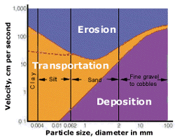 |
The eastern United States is a living, life-sized tribute to
the action of water and rivers. Fast moving water can move
very large particles, as this diagram shows. As water slows down, it
starts to deposit particles. This power of flowing water was evident
in the wake of hurricane Ivan.
Diagram
shows threshold stream velocities for erosion, transportation and
deposition of varying particle sizes. A higher water
velocity is required to erode clay and silt than to move sand. |
|
|
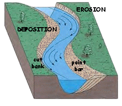
As a river flows, it
deposits sediments at intervals. These deposition spots change the
velocity of the river and encourage the deposition of more sediments.
The river soon takes on a winding, meandering shape as continued
erosion and deposition occur.
Erosion
and deposition patterns on a meandering stream are shown at right.
Erosion of the cutbank and deposition of a point bar on the slip-off
slope is illustrated. Arrow length is proportional to stream velocity.
These forces of erosion and
deposition happen continually.
|
|
|
Sometimes the effect of these processes
is obvious overnight after a torrential rain. Other times, the subtle
movement of the streamcourse may not be visible at all in the course
of a human lifetime. However, rivers always move. Human attempts to
confine and alter the flow of river are usually not successful in the
long run. It is wiser to stay out of the floodplain and build in
upland locations.
|
|
|
|
In
most areas of the Eastern United States, groundwater occupies the pore
spaces between soil particles at some depth below the surface. These
deposits can be fairly small, or enormous underground reservoirs, or
aquifers. Near streams and wetlands, the watertable is usually very
close to the surface. Streams and the watertable have a cooperative
relationship. After a rain when the rivers are full, they recharge the
underground water supply. When the streams run dry in the summer, the
groundwater feeds the stream to support the aquatic environment that
lives there.
|
 |
When groundwater is extracted for residential,
commercial, and industrial uses the watertable can be altered. This
means the water resides further from the surface than it once did. If
more and more water is taken out, eventually the groundwater supply
may be exhausted. Under natural conditions, precipitation would
percolate through the soil and continually recharge the groundwater.
However, in cities, the precipitation is usually piped away as runoff
and released in a different area, or so quickly that it cannot seep
back into the ground.
|
|
|
|
Under
almost all situations, rainfall results in some amount of runoff. Any
water that cannot immediately seep into the ground flows downslope as
runoff. Ground permeability affects runoff significantly. Hard packed
clay soils, such as those prevalent in the Chartiers watershed, absorb
very little water while a loose sand might absorb almost all the
precipitation that falls onto it. The amount of runoff is
related to the amount of rain a region experiences.
However,
urban and rural areas experience the effects of runoff very
differently. The presence of vegetative cover slows the journey of
raindrops from sky to soil and reduces the amount of runoff.
Impermeable surfaces, such as concrete, absorb almost no water at all.
The management of storm runoff is a significant issue in cities,
especially when considering the destructive power of raging water.
|
| The
amount of storm water runoff is calculated by the equation at
right.
The runoff coefficient C is calculated based on the permeability of the
ground surface. |
Q=CIA
Q = peak runoff rate
C = runoff coefficient
I = rainfall intensity
A = drainage area (acres)2 |
| Some types of surfaces encountered in a typical
urban area are shown below:

|
Note
that the C value for unimproved areas (forests, native meadows) is
very low, almost all the water is absorbed. The C value for downtown
areas containing a lot of asphalt, concrete, and roof surfaces is very
close to 1.0, which means almost all of the water runs off these
surfaces. Impermeable urban areas can create huge volumes of
stormwater runoff.
Cities
have a large proportion of paved areas and few natural areas with
trees and shrubs. Because so much of the city surface is impervious to
water, most of the precipitation that falls flows away as runoff.
Urban storm runoff is usually directed through storm sewers,
eventually emptying into nearby rivers. Under pre-urban conditions,
much of this volume of water would have absorbed into the ground.
Riverbeds often cannot accommodate this increased volume of water and
massive flooding results downstream from urban areas.
|
 |
|
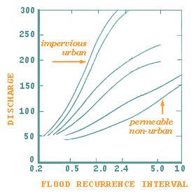
The
graph above illustrates that the risks of severe flooding and flood
frequency increase with the percentage of area impervious to water as
a result of paving and urbanization.
|
|
|
|
|
In
urban and suburban areas, much of the land surface is covered by
buildings and pavement, which do not allow rain and snowmelt to soak
into the ground. Instead, most developed areas rely on storm
drains to carry large amounts of runoff from roofs and paved areas to
nearby waterways. The stormwater runoff carries pollutants such as
oil, dirt, chemicals, and lawn fertilizers directly to streams and
rivers, where they seriously harm water quality. To protect
surface water quality and groundwater resources, development should be
designed and built to minimize increases in runoff.
|
HOW URBANIZED AREAS AFFECT WATER QUALITY
|
 |
increased
runoff |
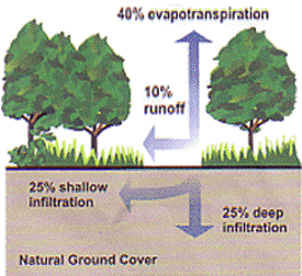
The
porous and varied terrain of natural landscapes like forests,
wetlands, and grasslands traps rainwater and snowmelt and
allows them to filter slowly into the ground. In
contrast, impervious (nonporous) surfaces like roads, parking
lots and rooftops prevent rain and snowmelt from infiltrating,
or soaking, into the ground. Most of the rainfall and
snowmelt remains above the surface, where it runs off rapidly
in unnaturally large amounts.
|
 |
|
Storm
sewer systems concentrate runoff into smooth, straight
conduits. This runoff gathers speed and erosional power as
it travels underground. When this runoff leaves the storm
drains and empties into a stream, its excessive volume and power
blast out streambanks, damaging streamside vegetation and wiping
out aquatic habitat. These increased storm flows carry
sediment loads from construction sites and other denuded
surfaces and eroded streambanks. They often carry higher
water temperatures from streets, roof tops, and parking lots,
which are harmful to the health and reproduction of aquatic
life. The loss of infiltration from urbanization may also
cause profound groundwater changes. Although urbanization
leads to great increases in flooding during and immediately
after wet weather, in many instances it results in lower stream
flows during dry weather. Many native fish and other
aquatic life cannot survive under these conditions. |
|
increased
pollutant loads |
Urbanization
increases variety & amount of pollutants carried into
streams, rivers, and lakes. The pollutants include:
- Sediment
- Oil,
grease and toxic chemicals from motor vehicles
- Pesticides
and nutrients from lawns and gardens
- Viruses,
bacteria and nutrients from pet waste and failing septic
systems
- Road
salts
- Heavy
metals from roof hingles, motor vehicles and other sources
- Thermal
pollution from dark impervious surfaces such as streets
and rooftops
|
|
These
pollutants can harm fish and wildlife populations, kill native
vegetation, foul drinking water supplies,and make recreational
areas unsafe and unpleasant. Chartiers Creek and many of
its tributaries in the lower watershed are adversely impacted by
these urban pollutants. |
|
MANAGING
URBAN RUNOFF
|
|
what
can homeowners do? |
To
decrease polluted runoff from paved surfaces, households can develop
alternatives to areas traditionally covered by impervious
surfaces. Porous pavement materials are available for driveways
and sidewalks, and native vegetation and mulch can replace high
maintenance grass lawns. Homeowners can use fertilizers
sparingly and sweep driveways, sidewlks and roads instead of using a
hose. Instead ofdisposing of yard waste, you can use the
materials to start a compost pile. And homewoners can learn to
use Integrated Pest Management (IPM) to reduce dependence on harmful
pesticides.
In
addition, households can prevent polluted runoff by picking up after
perts and using, storin and disposing of chemical properly.
Drivers should check their cars for leaks and recycle their motor oil
and iantifreeze when these fluids are changed. Drivers can also
avoid impacts from car was runoff (e.g. detergents, grime, etc.) by
using car wassh facilities that do not generate runoff.
Households served by septic systems should have them professionally
inspected and pumped every 3 to 5 years. They should also
practice water conservation meatsures to extend the life of their
septic systems.
|
controlling
impacts from new development |
Paddlers
on the canoe sojourns did not fail to notice the streamside
development with houses sprouting like mushrooms after a spring rain
along the banks of Chartiers Creek. Low impact development
includes measures that conserve these natural areas, particularly
sensitive hydrologic areas like the streambank riparian buffers and
infiltrable soils. Developers and city planners must attempt to
control the volume of runoff from new development by using these low
impact development, structural controls, and pollution prevention
strategies. They can reduce development impacts and reduce site
runoff rates by maximizing surface roughness, infiltration
opportunities and flow paths.
|
controlling
impacts from existing development |
How
about our current floodplain and watershed communities?
Controlling runoff from existing urban areas is often more costly than
controlling runoff from new developments. Economic efficiencies
are often realized through approaches that target "hot
spots" of runoff pollution or have multiple benefits, such as the
high efficiency street sweeping which was instituted in Crafton, that
addresses aesthetics, road safety and water quality.
Urban
planners, city managers and others responsible for managing urban and
suburban areas can first identify and implement pollution prevention
strategies and examine source control opportunities. They should
seek out priority pollutant reduction opportunities, then protect
natural areas that help control runoff, and finally begin ecological
restoration and retrofit activities to clean up degraded water bodies.
In many communities in the Chartiers Watershed, these efforts are
spearheaded by local conservation organizations, in cooperation with
their local government and Environmental Advisory
Councils.
Local
governments are encouraged to take lead roles in public education
efforts through public signage and pollution prevention outreach
campaigns. Crafton and Greentree have marked storm drains, while
Scott and South Fayette Townships have partnered with their local
conservation groups in acquiring, preserving and remediating natural
areas and promoting and enacting model ordinances.
Citizens
can help prioritize the clean-up strategies and volunteer to
become involved in restoration efforts, which often starts with their
local conservation group..
|
read
more |
REDUCING
STORMWATER RUNOFF The
Penn State Cooperative Extension has urban and community forestry
information for municipalities, community-based organizations and
homeowners in the form of a central clearinghouse website for all
things related to forests
and watersheds. There have been many recent efforts towards
managing urban forests for watershed health that have resulted in a
variety of highly useful tools and training materials. This site
compiles these resources into a format that can be easily accessed and
downloaded.
Visit
ARTEMIS, the green building supply center in Lawrenceville, on our Links
page, to build and remodel greener. The US EPA, in cooperation with 3 Rivers Wet Weather have
also included these related on-line publications on water quality and
stormwater management:
TURN
YOUR HOME INTO A STORMWATER POLLUTION SOLUTION
This website links to an EPA homewoner's guide to healthy habits for
clean water that provides tips for better vehicle and garage care,
lawn & garden techniques, home improvement, pet care, and more...
NATIONAL
MANAGEMENT MEASURES TO CONTROL NONPOINT SOURCE POLLUTION FROM URBAN
AREAS This
technical guidance and reference document is useful to local, state
and tribal managers in implementing management programs for polluted
runoff. Contains information on the best available economically
achievable means of reducing pollution of surface waters and
groundwater from urban areas.
ONSITE
WASTEWATER TREATMENT RESOURCES This site contains the latest
brochures from EPA for managing onsite wastewater treatment systems
such as conventional septic systems and alternative decentralized
systems. These resources provide basic information to help
individual homeowners as well as detailed, up-to-date technical
guidance of interest to local and state health departments.
LOW
IMPACT DEVELOPMENT CENTER This center provides information on
protecting the environment and water resources through integrated site
design techniques that are intended to replicate pre-existing
hydrologic site conditions.
STORMWATER
MANAGERS RESOURCE CENTER Created and maintained by the Center for
Watershed Protection, this resource center is designed specifically
for stormwater practitioners, local government officials and others
that need technical assistance on stormwater management issues.
COMMUNITY
RESPONSES TO RUNOFF
The National Resources Defense Council developed this interactive web
document to explore some of the most effective strategies that
communities are using around the nation to control urban runoff
pollution. This document is also available in print form and as
an interactive CD-ROM.

|