|
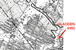
Mine maps were identified for most of the discharges in detail, enough that the probable extent of mine pools and their paths could be established. |
|
|
The extent of mine drainage zones was also established. The mine discharges drain approximately 16,000 acres (excluding Coal Run) of abandoned mines. Most of the mines had an average recharge of about 0.15 gpm/acre of mine drainage area. The two exceptions were Gladden and Wingfield Pines discharges (the highest flows by total volume, but having the lowest recharge area), which were closer to 1.0 gpm/acre of mine drainage area. |
|
|
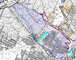
This mine map and information adds a new and significant dimension to AMD remediation. It can be used to determine not only the best, but also a technically feasible location for treatment. The most important consideration for passive treatment is land area, not volume. Suitable land area that is close to these discharges is a scarce resource. Understanding the mine sprawl and contours may suggest ways of re-engineering discharges to accommodate available areas for remediation. |